The best Byron Bay walks and hikes to go on this summer

hero media
Lace-up your boots and head out for a walk or hike to best appreciate Byron Bay.

The best Byron Bay walks and hikes are those that take in the spectacular scenery. From a dog-friendly beach to a legendary coastal path that squiggles along the craggy coastline to paths through photogenic pockets of rainforest, and a guided tour of a glow-worm tunnel, there are walks and hikes around Byron Bay designed to suit both casual walkers and serious hikers. We’ve done some of the hard work for you, rounding up some of the best spots to take a hike in Byron Bay and beyond. 

Snap a selfie along the Cape Byron walking track

an aerial view of the Cape Byron walking track
The 3.7-kilometre loop will reward you with spectacular views of the ocean and hinterland. (Image: Destination NSW)

Have you even been to Byron if you haven’t snapped a selfie in front of the iconic Cape Byron Lighthouse? You will find some of the best of what Byron has to offer along the 3.7-kilometre walk: from sun-drenched beaches to coastal rainforest and plenty of whales to spot when the season is right. There are also cafes along the way where you can stop and fuel up on pancakes and piccolos. 

You can extend the walk – and burn off those calories – by starting at Clarke’s Beach, walking along the sand to The Pass, joining the Palm Valley track until you go over the cliffs to Wategos Beach before joining the track to the lighthouse. This is not a pram-friendly walk; there are a lot of stairs. While the road from Byron Bay runs right to the back of Wategos Beach, it can get very crowded and parking is extremely limited. 

Take your pooch along for the Tallow Beach walk

a scenic view of the Tallow Beach from above
Tallow Beach extends to the Arawkal National Park. (Image: Destination NSW)

Slather yourself in 50-plus to walk to and fro along Tallow Beach, which curves for about seven kilometres between the Cape Byron Conservation Area and Broken Head Nature Reserve. The beach, just 3.2 kilometres from the heart of Byron Bay, is part of Arawkal National Park and one of the only places that matter when there’s big surf. In the early mornings, when the birds are singing, and the horizon looks as though it’s covered in a layer of gauze, you will see the ghostly silhouettes of fishermen casting their lines out to sea. The dog-friendly section of the beach stretches from a point adjacent to Jarman Street to the boundary of the national park. 

Embark on the Three Sisters walking track
the Kings Beach, Three Sisters Walking Track
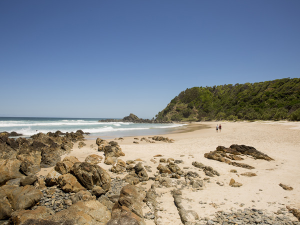
You’ll pass through the secluded Kings Beach along the Three Sisters Walking Track. (Image: Destination NSW)

The starting point for the Three Sisters Walking Track is at the southern end of the picnic area at Broken Head Nature Reserve. The easy 1.6-kilometre walk has gentle hills, and a few steps that will steer you through the emerald-green rainforest with carpets of moss to a lookout over Broken Head and the secluded Kings Beach. A quick heads up, though, Kings Beach is a clothing-optional affair. The area is rich in Indigenous history, which you can read about on the clearly signposted walk, which tells the story of the three sisters who were turned into rocky outcrops near the headland. In winter and spring, the walk offers great vantage points to spot whales and watch for white-bellied sea eagles spearing into the sea for food. 

Need tips, more detail or itinerary ideas tailored to you? Ask AT.

AI Prompt

Visit a glow-worm tunnel in Nightcap National Park
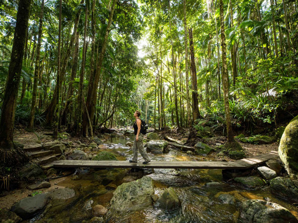
a man walking along the rainforest trail in Nightcap National Park
Tackle the tranquil rainforest trails in Nightcap National Park. (Image: Lismore City Council)

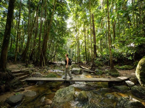
It’s not just the coastal walks that boast epic scenery around Byron Bay. Head to the hinterland and you will find a range of trails – from the tranquil to the well-trodden. The World-Heritage-listed Nightcap National Park is home to the distinctive curved silhouette of the ancient volcano, Wollumbin/Mount Warning, which rises above the landscape. Book a Hinterland Magic and Glow-worm Experience and you will be led to a tunnel lit up by the luminescent beetles. The tour also winds its way to a waterfall for a swim and to a rainforest temple hidden in the hinterland.  

Look out over Lennox Head along the Coastal Recreation Walk

a surfer heading to the beach, Lennox Head
The popular surfing spot attracts many local surfers. (Image: The Legendary Pacific Coast)

Lennox Head is a 30-minute drive south from Byron and worth the detour to enjoy more great views of sky and sea. Do as Lennox locals do on the daily and walk to the top of Lennox Point, known locally as ‘The Point’. The path is very prominent as it hugs the coast and follows the shoreline. Head south, past groves of pandanus palms, until you reach Pat Morton Lookout, which passes the point break, where you will see talented local surfers all lined up waiting to conquer the next wave. 

The views from the Lennox Head lookout span north across Lennox Head and Seven Mile Beach and south to Rocky Point and Boulders Beach and Skennars Head and, if you’re lucky, you might spot the resident dolphins who also like to surf the waves. 

Minyon Falls Walking Track

the Minyon Falls in Nightcap National Park
The 100-meter waterfall cascades over ancient rhyolite cliffs. (Image: Destination NSW)

Strike out beyond the well-worn tracks along the Byron Bay seafront to enjoy a glorious hinterland adventure along the Minyon Falls Walking Track. The path unfurls through the ancient emerald-green rainforest of Nightcap National Park until it reaches the lookout where you can peer over the top of the cliffs cloaked with Australian eucalyptus trees to see Minyon Falls tumble down into a beautiful natural swimming pool. A bit of rock-hopping is required to reach the base of the waterfall, which is most impressive after heavy rain. 

Pinnacle Walk

view of the Border Ranges from The Pinnacle lookout
The Border Ranges can be seen from The Pinnacle lookout. (Image: Destination NSW)

The forested peak of Wollumbin can be glimpsed from plenty of vantages around Byron and the Tweed, but to really appreciate this ancient sentinel, take the Pinnacle Walk in the Border Ranges National Park. While keen hikers could once clamour to the summit, in recent years, the local Bundjalung people have closed this sacred site to tourists for safety and cultural conservation reasons. But you can still hike the foothills of this monolith and admire its majesty from the easy 600-metre return Pinnacle Walk and Lookout. Our hot tip is to rise before the sun to see Wollumbin emerge from the darkness. 

Weekly travel news, experiences
insider tips, offers, and more.

Rocky Creek Dam

Pack your picnic basket for day at pretty Rocky Creek Dam, just a short side-step west of the Byron Shire. There are four walks to wander, ranging from the quick, 20-minute Water Dragon Walk to the 2-hour Scrub Turkey Walk, so you can pick the route that suits your group. Once you’ve absorbed your bush-hemmed surrounds and marvelled at the 14,000-mega-litres of water held by the dam, sprawl out in the picnic area and let the kids loose in the adventure playground.  

Killen Falls
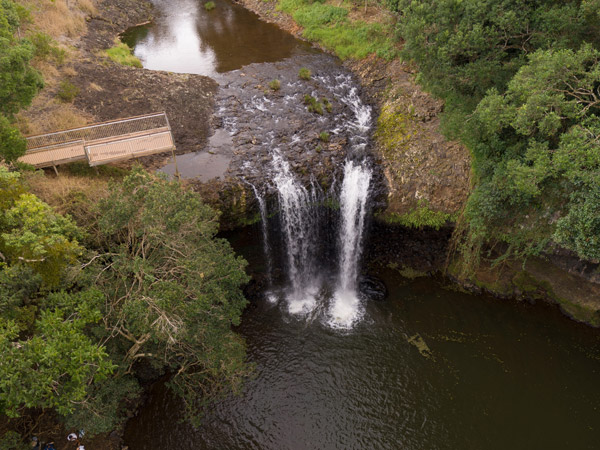
an aerial view of Killen Falls
The waterfall is hidden in the hinterland between Byron Bay and Ballina. (Image: Destination NSW)

If you’d like to soak in some lost world magic, take a drive to Tintenbar. Tucked into the hinterland of the Ballina Shire, this serene and mostly secluded spot offers an easy 660-metre return walk to a viewing platform or a fairly steep 1-kilometre hike down to the base of the waterfall. Take a deep inhale as you tune into the mind-stilling sound of the thundering cascade. 

Tyagarah Nature Reserve and Tea Tree Lakes
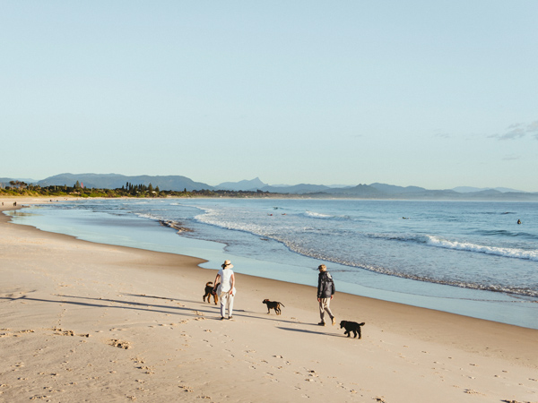
two people walking with dogs on Belongil Beach
Go for a leisurely walk with your furry friends on Belongil Beach. (Image: Destination NSW)

Set between Byron and Brunswick Heads, Tyagarah Nature Reserve unfurls along a 7-kilometre stretch of sand. Behind the dunes, there are bush-hemmed tracks for proficient walkers, which take in tranquil tea tree lakes and a picnic area. If you’re eager to lace up for a longer hike, start the walk at Brunswick Heads and carry along to the north end of Byron at Belongil Beach. This 15.4-kilometre stretch will take a good few hours, so be prepared with water, food and sun protection, and don’t forget to tell someone where you’re headed.  

Northern Rivers Rail Trail

For now, the quickly beloved Rail Trail kicks up the dust just north of Byron at Crabbes Creek, but planning is in the process to link the Tweed section to Byron and beyond. Until then, the current trail meanders beautifully through bucolic vistas, beneath rainforested canopies, and through former rail tunnels (one of which features a smattering of glow worms). While bikes are the most popular way to tackle the trail, you can also hike the full 24 kilometres or bite-size sections on foot. Just watch out for two-wheeled hoons! 

Discover the best beaches in Byron Bay.

This article was originally written by Carla Grossetti with updates by Lara Picone.

Want to see more stories from Australian Traveller in your Google search results?

  1. Click here to set Australian Traveller as a preferred source.
  2. Tick the box next to "Australian Traveller". That's it.
Carla Grossetti
Carla Grossetti has written across print and digital for Australian Traveller and International Traveller for more than a decade and has spent more than two decades finding excuses to eat well and travel far. A prestigious News Corp cadetship launched her career at The Cairns Post, before a stint at The Canberra Times and The Sydney Morning Herald gave way to extended wanders through Canada, the US, Mexico, Central America, Asia and Europe. Carla was chief sub editor at delicious and has contributed to Good Food, Travel & Luxury, Explore Travel, Escape. While living in London, Carla was on staff at Condé Nast Traveller and The Sunday Times Travel desk and was part of the pioneering digital team at The Guardian UK.
View profile and articles
hero media

This stretch of Sydney beaches topped the annual Best Australian Beaches list

    Carla Grossetti Carla Grossetti
    Bate Bay’s sweep of beaches has been crowned Australia’s best for 2026, placing Sutherland Shire in the spotlight as a top coastal destination just south of Sydney’s CBD.

    The beaches fringing Bate Bay – Cronulla, North Cronulla, Wanda, Elouera and Greenhills – have topped Tourism Australia’s 2026 list of best Australian beaches (as curated by Beach Ambassador Brad Farmer). For locals, it’s less revelation, more recognition.

    The mood shifts from the moment you step off the T4 train service from Central to Cronulla and catch a glimpse of the ocean. At dawn, the Esplanade is already buzzing with regulars, and by mid-morning, parents have staked out a toasty spot on Cronulla Beach where excited toddlers clamber over rocks, and the Jellybean swim squad at Oak Park have donned their bright pink caps while singing Oh, What a Beautiful Mornin’.

    By the afternoon, towels are being collected from across the sand as visitors wander back to Cronulla in loose formation.

    North Cronulla beach
    Dive into the world’s best beaches.

    That’s the thing about Bate Bay beaches. This isn’t a story about a single beach. This long, uninterrupted sweep of sand and sea, where you can walk for kilometres without breaking stride, is not just enjoyed over summer; it’s a year-round destination. Here, Cronulla’s buzz gives way to Wanda’s wild edges, before stretching out to the quieter reaches of Greenhills.

    But while Bate Bay’s beaches may have taken top honours in the 2026 Best Australian Beaches list, they’re only part of the drawcard. Sutherland Shire stacks up as a full-spectrum coastal escape, where good food, national park adventures and on-the-water experiences sit within easy reach of the shoreline. Whether you’re planning a long weekend or stretching out a stay, here’s how to make the most of Cronulla beyond the sand, sea and surf.

    Beyond the beaches

    Dining

    the dining room at Pippis Cronulla
    Enjoy a sundowner by the sea at Pippis Cronulla.

    The Sutherland Shire dining scene delivers from early morning to late at night with a mix of vibrant cafes, bars and pubs. Start your day at Grind Espresso, where the coffee comes strong and fast. From there, drift towards HAM for pastries, best eaten buttery warm.   

    By midday, locals linger across sun-lit tables. Loaf and Next Door appeal to the surfers who come in for snacks after chasing waves. Blackwood’s Pantry and The Press are also popular for breakfast and lunch, while Pilgrim’s continues to hold a special place in the hearts of vegans.

    Newer arrivals signal where Cronulla is heading: Homer Rogue Taverna is being hailed as one of the best restaurants in Cronulla, with the confidence that comes from understanding what locals want. Ask a local to reveal their favourite restaurant for a special occasion, and it’ll likely be Pino’s Vino e Cucina al Mare, Yalla Sawa or Alphabet Street. Summer Salt, Sealevel, Benny’s, Bobbys and Pippis are a few of the best waterfront restaurants in the Shire.

    Finally, when most places are winding down, Duke’s Providore shifts gears to become Duke’s After Hours – a low-lit romantic spot perfect for a date night. Parc Pavilion, Northies Cronulla and bars The Blind Bear, Las Chicas and Low & Lofty’s are also part of Cronulla’s identity.

    Visit Bundeena

    Bundeena Ferry Wharf
    Catch a ferry to Bundeena.

    A short ferry ride from Cronulla, Bundeena offers a counterpoint to Cronulla’s mighty surf beaches. If Cronulla is the Shire’s social heart, Bundeena – or Bundenesia, as it’s affectionately known – is the place to go to exhale and unwind.

    Hop on the ferry from Cronulla, and within 30 minutes, you’ll be inhaling the eucalyptus-scented air. Check the creative pulse of the local community by timing your visit with the Bundeena Maianbar Art Trail on the first Sunday of every month.

    One of the best things to do in Bundeena is paddle into Cabbage Tree Basin with Bundeena Kayaks. Follow the five-kilometre Jibbon Beach Loop Track that leads past quiet coves to ancient Indigenous rock art, or simply find a stretch of pearl-white sand to relax on.

    Pristine walking trails

    Royal National Park Cape Baily Walking Track
    Cool off with a coastal stroll.

    Beyond the coastline, Sutherland Shire offers myriad ways to shift gears. Royal National Park – the oldest national park in Australia – sits just minutes from the surf. Clifftop walks trace the edge of the continent, the rugged bushland is threaded with creeks and hidden waterfalls, and a network of tracks rewards those willing to go a little further.

    Take the Coast Track, where the land drops cleanly into the ocean over sheer cliffs that have been stacked together like giant Jenga. Or veer inland, where pockets of forest cool the air and filter the light. It’s a reminder of how close nature sits to the bustle of suburbs in the Sutherland Shire.

    Enjoy whale watching

    humpback whale sighting noosa experiences
    Spot whales from May to October. (Credit: The Edit Suite)

    Twist your binoculars until the ocean is in focus, stretched like a creased blue sheet all around.  Come May, the East Coast becomes the humpback highway. Thousands of whales migrate along this stretch of coastline each year, their movements tracked by keen eyes from vantage points like the Cape Solander platform in Kamay Botany Bay National Park, one of the best places for whale watching in Australia. There’s something quietly thrilling about seeing that first telltale spout or the arc of a breaching body against the vastness of the sea. From June to October, whale-watching cruises depart from Cronulla, offering a closer look at the migration.

    Awards come and go. But places like Cronulla endure because they belong as much to the visitors as they do the early-morning swimmers, walkers and surfers.

    Plan your escape at visitsutherlandshire.com.au.