Camping Adventure at West Alligator Head

hero media
Australian Traveller looks at the remote camping outpost of West Alligator Head in NT’s Kakadu National Park.

When it comes to camping, we’ve tried to find one site that’s as off-the-beaten-track as possible. Hardy travellers Steve and Alison Kruger reckon it’s hard to go past this remote area of Kakadu.

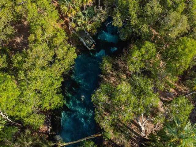
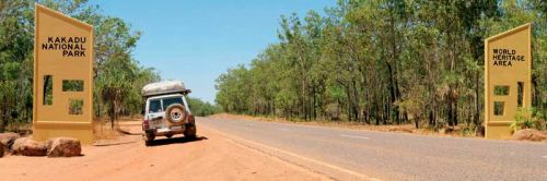
West Alligator Head is a fishing and birdwatching paradise. Getting there is a short but challenging 4WD trek on the Waldak Irrmbal Track southeast of Darwin. The track leaves the Arnhem Highway just 2km inside the North Western Entrance to the World Heritage-Listed Kakadu National Park. This area has limited access, as the track crosses the dark soils of the Wildman and West Alligator River flood plains, which remain water saturated months after the end of the wet season.

The 81km drive into West Alligator takes you past two good camping spots on the Wildman River: 2 Mile and 4 Mile Waterholes, named for their length, not their distance from the turnoff. These are both fresh waterholes with their own bush camping areas. But, frankly, once you’ve experienced the paradise ahead, you’ll decide to stop at the waterholes for a spot of morning tea or a quick overnight camp only. Take care after the turnoff to 4 Mile Waterhole, as the track becomes more narrow, winding and corrugated.

Engage 4WD to tread lightly and to ensure you don’t damage the track. Additionally, decreasing your speed will ensure you don’t flick up one of the many sticks on the edge of the track that can easily stake a tire or damage your undercarriage. The track can become impassable after wet weather for months at a time, so be sure to keep one eye on the skies during your visit or you’ll end up staying a lot longer than you’d planned.

As the track winds its way through the dry savannah woodlands for which the area is famous – and through various fire-scorched sections – you’ll encounter groves of screw top palms; these have the appearance of a giant screw, which becomes very obvious when the old foliage has been burnt from their tops.

Finally the woodlands yield to the flood plains of the local rivers and are replaced by tall grasses. When this vegetation is burnt out by one of the many fires common to the area, it quickly sprouts anew, becoming as green as the grass on a well-watered suburban front lawn. This lends a hint as to the moisture that exists just a few centimetres below the surface. It’s always a striking contrast between the charred and blackened remains of the burnt grass and the verdant green of new growth. Once you cross the plains, you quickly find yourself 4WDriving along the edges of sand dunes towards the beach, once again surrounded by savannah woodlands.

Camping is only permitted in three areas at West Alligator Head, on a first-come first-served basis. The smallest area will accommodate only two vehicles and the largest some 30 or so. The pick of the camping areas isn’t Pocock Beach, but a small private secluded beach on the eastern side of the headland. This site accommodates about five vehicles. The 4WD across the headland to this beach takes you through a monsoon forest in which kangaroos, wallabies, bush turkeys, birdlife and flying foxes are plentiful.

Upon reaching this secluded cove, you’ll find that the high tide mark is so close to your campsite that you’ll be able to cast a line to catch that barra or salmon and still be only a few metres from your esky, fireplace and sleeping bag. Keep in mind: when you’re beaching your boat, there’s a huge difference between the high and low tide marks in this area, and once the tide retreats all you’re left with is soft mud.

From October to December is turtle nesting season; they use the beach dunes for nesting, so 4WDs aren’t allowed on the sand except to launch boats. If you take your torch and you’re careful, you just might find a nesting site. But please remember that they’re protected and easily frightened. Something else to keep in mind is that these are crocodile-infested waters; sightings along the beach are common, including reports of a 4.5m croc in the area, so swimming is far from recommended.

Birdlife abounds in this area, with the blue-winged kookaburras being particularly friendly. These cheeky devils have the ability to hold a hermit crab in their beaks, which they then smack onto a branch until the borrowed shell is broken. The unprotected crab then falls to the ground and the kookaburra swoops down to eat its waiting meal.

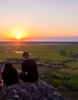
If your visit happens to coincide with a rising full moon, you’ll be treated to the visually spectacular scene of a huge, red, glowing orb lighting up your private cove and beach. The colours are strong and reflect from the calm ocean as though set on fire.

You never know who you might bump into in this idyllic paradise. During our last stopover, our camp was visited by the guys from HEMA (map-makers extraordinaire) in their Map Patrol vehicle. Over a cup of coffee, Charles and Keith told of their work. Surely they must have one of the best jobs in the world! They were replotting the route into West Alligator Head with GPS units for the next series of maps of the area. So make sure you visit before this secret is out and paradise is lost.

DETAILS // West Alligator Head

Getting There // The track leaves the Arnhem Highway 2km inside the North Western Entrance to Kakadu National Park, 170km southeast of Darwin.
Best Time To Visit // August to October – but be sure to check if the track has re-opened following the end of the wet season.
Permits // No permits are required as long as you camp within designated camp areas.
Camping // Camping is free and in designated areas only. Fires are allowed only in the cement rings provided. Be aware of any fire bans that may be in place.
Amenities // Basic in the main camping area at West Alligator Head, limited or none in the Pocock Beach, 2 and 4 Mile Waterhole areas. No drinking water available, and no rubbish disposal provided – so please take all your rubbish out with you.

hero media

8 Red Centre locations to explore after seeing the new movie, Kangaroo

Spend a few days visiting the real-life Central Australian locations that inspired the new film everyone is talking about, and discover why Alice Springs is such an important part of Australian culture.

In the credits of the new Australian film Kangaroo , the first name under ‘cast’ should read ‘The Northern Territory ’. Not only is Alice Springs (and the surrounding landscape) integral to the movie itself, but the spiritual heart of Australia and its local Indigenous owners also inform the look and feel of every frame, explains Producer Trisha Morton-Thomas of Brindle Films, who also plays Charlie’s grandmother Gwennie.

“By setting Kangaroo in Alice Springs (Mparntwe), the film embraces how visible Aboriginal people are here, and the living Aboriginal culture that is woven through this community,” she explains.

still from kangarro film
See Kangaroo, then visit the real-life filming locations.

And while shooting in such a sacred part of the Northern Territory required extra planning, it was something the cast and crew were highly invested in.

“There are incredibly significant sacred sites and places of deep cultural stories in the area, that at times are very gender-specific, which we’ve kept out of the production,” she explains. “Even if overhead drone footage captures a sacred site that isn’t meant to be seen by other people outside of that clan, we’ve made sure to omit it from the film.”

If Kangaroo piqued your interest in a Central Australian holiday, we don’t blame you. Read on to discover eight places featured in the movie that you can visit in real life – and get planning. Don’t forget to pack sunscreen and a hat.

1. Alice Springs/ Mparntwe

artist at Many Hands Art Centre
Visit the galleries of Alice Springs, like Many Hands Art Centre. (Image: Tourism NT/ Helen Orr/ Many Hands Art Centre)

The red and dusty streets of the film’s fictional town of Silvergum were filmed on the outskirts of Alice Springs. And, while the art gallery featured in the film is fictional, Alice Springs is a hub of creativity. See the work of local artists at the Araluen Art Centre , Yubu Napa Art Gallery , Iltja Ntjarra (Many Hands) Art Centre and the famous Tjanpi Desert Weavers .

2. The Kangaroo Sanctuary & Kangaroo Rescue Centre

The Kangaroo Sanctuary Alice Springs, the inspiration for the Kangaroo move
Visit the movie’s inspiration at Kangaroo Sanctuary. (Image: Tourism NT/ Kangaroo Sanctuary)

Kangaroo was inspired by the journey of Chris ‘Brolga’ Barns, who founded the now world-renowned Kangaroo Sanctuary based in Alice Springs. For lead actor, Aussie Ryan Corr, the animals were central to the movie, alongside the landscapes.

“The animals in this story were a real calling point for me,” he explains. “What this story tries to tell us about the connection between humans and animals is beautiful.”

To gain a real insight into the fauna and flora of the Red Centre, you can visit the Kangaroo Sanctuary on a sunset tour, where you might even get the chance to hold a baby kangaroo.

3. Ormiston Gorge

woman walking along the edge of Ormiston Gorge near alice springs
Take a dip in Ormiston Gorge. (Image: Tourism NT/ @domandjesso)

The film captures the raw beauty of the West MacDonnell Ranges, known in the Arrernte language as Tjoritja. This national park is rich in Indigenous culture and stark geological wonders.

Only a 15-minute drive from Alice Springs, Tjoritja offers visitors the chance to camp, hike and swim among ancient landscapes (most attractions are less than a three-hour drive away).

Ormiston Gorge , a cooling oasis in among the red desert sands, is one of the most popular destinations, no doubt because of the permanent swimming hole and towering red cliffs. From here, visitors can also embark on the beautiful Ormiston Pound Walk and the shorter – more accessible – Ghost Gum Walk. Bring your bathers – it’s safe for swimming.

4. Standley Chasm

woman walking through Standley Chasm near alice springs
Wander through Standley Chasm. (Image: Tourism NT)

The 1.2-kilometre walk to nearby Standley Chasm will be a highlight for any visitor as the imposing 40 metre-high chasm walls project strength and ancient wisdom.

Visit at midday to experience the path illumined by the midday sun. Not only will you fill your camera roll with vibrant red images of the gorge and its intoxicating shadows, but you can also camp nearby in a powered or unpowered site so you can watch the brilliance of the desert stars fill the night sky after dusk.

5. Simpsons Gap

three people walking on path through simpsons gap near alice springs
Walk the trails of Simpson’s Gap. (Image: Tourism NT/ Helen Orr)

Closer to Alice Springs, the photogenic Simpsons Gap is the perfect place to spot the endangered Black-footed Rock wallaby near the permanent watering hole. While swimming isn’t permitted, soaking up the sun and views certainly is.

Explore the area’s numerous walking trails, appreciate the soaring cliffs on either side of the ‘gap’ and pick out the shooting locations of Kangaroo in the area.

6. Ellery Creek Big Hole

aerial of Ellery Creek Big Hole near alice springs
Dive into Ellery Creek Big Hole. (Image: Tourism NT/ Tourism Australia)

When it comes to classic Northern Territory landscapes, you can’t go past Ellery Creek Big Hole/ Udepata : tall gum trees sidling up to a refreshing watering hole (fed by the West MacDonnell Ranges and surrounded by rugged red cliffs.

Swim in the cooling waters, hike the cliff tops, watch for birds and even stargaze as you camp here overnight. It’s locations like this that attracted the film’s director Kate Woods to the project.

“It humbles you to be in this environment: it’s so beautiful, so old and so vast,” she explains. “I was thrilled to get a chance to … shoot such a beautiful story in the incredible landscape of the Northern Territory.”

7. Larapinta Drive

aerial of Larapinta Drive into alice springs
Drive along Larapinta Drive. (Image: Tourism NT)

There is no better way to get a feel for how the characters arrived at the fictional Central Australian town of Silvergum than to travel along the iconic state road, Larapinta Drive.

Connecting Alice Springs to the mighty King’s Canyon in the west, via the historic community of Hermannsburg, this road takes in the West MacDonnell National Park, Alice Springs Desert Park and artist Albert Namatjira’s house, among other attractions. Take your time, bring a camera and prepare for numerous stops along the way.

8. Todd River

competitors in Henley on Todd Regatta, alice springs
Join in the fun of the quirky Henley on Todd Regatta. (Image: Tourism NT/ TImparja Creative)

Meandering through Alice Springs like a lazy Western Brown snake, the Todd River is a central part of Alice Springs culture. Known as an ‘intermittent river’, the Todd can go from a dry dusty riverbed to a flowing waterscape in less than 15 minutes after heavy rainfall.

When it’s dry, the famous Henley on Todd Regatta fills the sandy riverbed with handmade ‘boats’ carried by sailors. This is the world’s only dry river boating event, and it’s referenced in the ‘Silvergum Boat Race’ in the movie. Inspired by the real-life event, the characters built quirky “Flintstones-style boats” and competed in teams.

See Kangaroo in cinemas now, and start planning your NT getaway at northernterritory.com.