hero media

Stunning waterfalls near Daylesford you need to visit

Credit: Visit Victoria

Marvel at these cascading falls.

There’s much more to Daylesford and its surrounds than spas and mineral springs; the area is also home to some of country Victoria’s most stunning waterfalls. From man-made spectacles to nature’s own display of power, have your camera ready to capture the beauty of these cascades.

Note: Check the Parks Victoria website for updates before visiting, as conditions can change quickly.

In Short

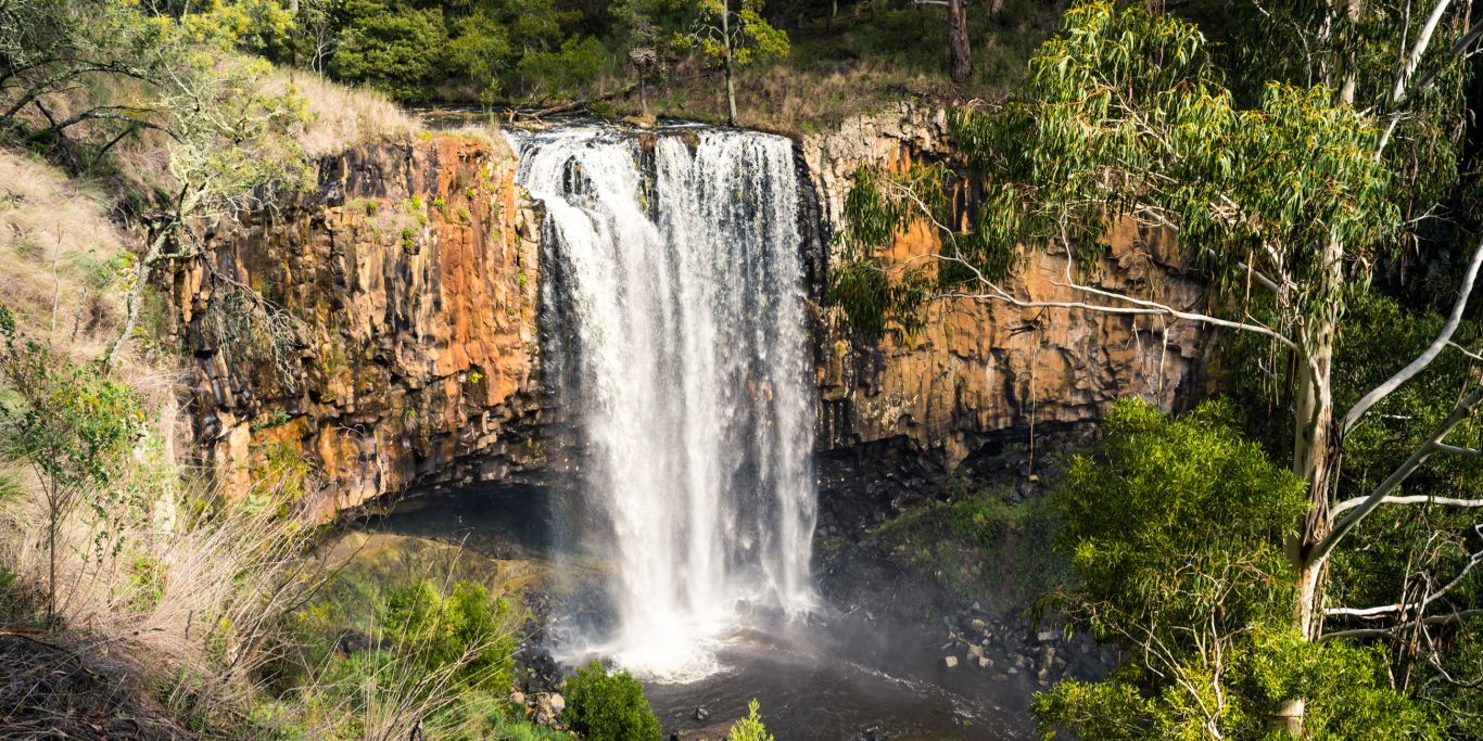
If you only visit one waterfall near Daylesford, make it Trentham Falls – the 32-metre cascade is one of the highest single drop waterfalls in Victoria.

Best time to visit waterfalls near Daylesford

To avoid viewing a waterfall when it’s just a trickle, visit in winter and spring, or after heavy rainfall. During this period, the falls are at their most powerful and impressive (just be aware tracks can be slippery, so wear sturdy footwear).

Best waterfalls to visit around Daylesford

Sailors Falls
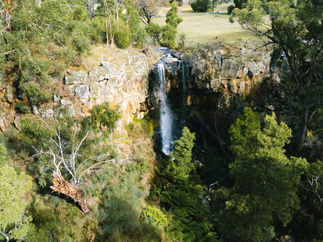
Sailors Falls, Daylesford
Sailors Falls drops into a lush, fern-lined gully. (Credit: Visit Victoria)

Widely believed to be named for the sailors who jumped ship seeking gold during the gold rush, Sailors Falls is about a 20-metre drop into a beautiful fern-lined gully (it splits into twin falls when the water is flowing well). You can view the falls from the picnic area (accessible for wheelchairs and strollers), or take the stairs down to a halfway vantage point, then to the base of the falls.

While you’re here, sample the fresh mineral water from the spring adjacent to the waterfall. You can skip the stairs for this, as there’s a tap in the picnic area (it’s pumped through a 135-metre bore, the only one to feature an electric pump). BYO lemons.

Distance from Daylesford: 7-min drive
Where: Ballan-Daylesford Rd, Sailors Falls
Parking: Yes
Difficulty: Easy to moderate
Swimming: No

Need tips, more detail or itinerary ideas tailored to you? Ask AT.

AI Prompt

Trentham Falls
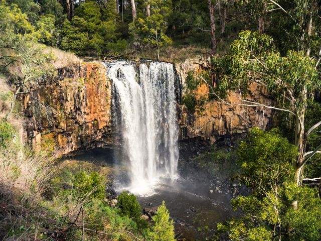
Trentham Falls, Daylesford
Trentham Falls plummets down a 32-metre-high basalt cliff. (Credit: Visit Victoria)

As one of the longest single drop waterfalls in Victoria, at some 32 metres cascading over sheer basalt rocks, Trentham Falls is a must-visit if you’re in the region. It’s located in the Coliban River Scenic Reserve, just outside of Trentham, set amongst native bushland.

The falls are a short walk from the car park; stick to the dedicated viewing platforms here, as the cliffs and base of the falls are unstable. Time your visit after rainfall for a truly spectacular showcase of nature’s force.

Distance from Daylesford: 18-minute drive
Where: Coliban River Scenic Reserve
Parking: Yes
Difficulty: Easy
Swimming: No

Loddon Falls
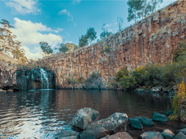
Loddon Falls, Daylesford
Loddon Falls is a spectacular gorge tucked within rolling hills and dirt tracks. (Credit: R Reeve)

We love the dramatic setting of Loddon Falls in Glenlyon, where water plunges over a rocky gorge into a swimming hole. When there’s enough water flow, it’s a fantastic spot for a swim, surrounded by the rugged gorge walls.

To get there from the car park, head through the gate and walk 10-15 minutes to the top viewing point; but if you want to reach the base and swimming hole, you’ll need to descend a steep, unformed track, so it’s best to have someone with you. Note that there are no picnic or toilet facilities here.

Distance from Daylesford: 15-minute drive
Where: Sewells Rd, Glenlyon
Parking: Yes, but access by 4WD only in wet weather
Difficulty: Moderate to challenging
Swimming: Yes

The Blowhole

The Blowhole is actually an artificial diversion tunnel on Sailors Creek – but that doesn’t sound as cool, nor does it accurately represent the sight of water gushing through when the river level is high.

The circular tunnel was dug out in the 1870s by gold miners so they could fossick in the area. It’s a short, accessible walk from the car park to the top of the falls area, or you can take stairs down to the bottom. Come for a picnic or a swim, and when water is low in the tunnel, you can even climb through.

Distance from Daylesford: 9-min drive
Where: Blowhole Walk, Hepburn
Parking: Yes
Difficulty: Easy
Swimming: Yes, dependent on water flow

Weekly travel news, experiences
insider tips, offers, and more.

Colbrook Reservoir
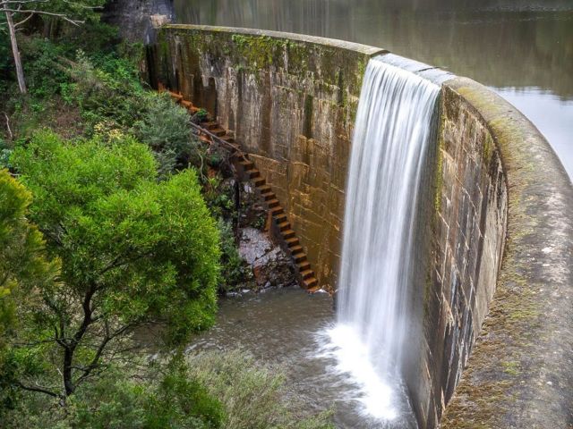
Colbrook Reservoir, Daylesford
Colbrook Reservoir cascades down a dam wall. (Credit: Daylesford Holiday Park)

This seasonal waterfall spills over the dam wall when water levels are high, especially after recent rainfall. To view the cascade from the bottom, carefully make your way down to Korweinguboora Creek and walk back upstream to the base of the dam wall.

Colbrook Reservoir is considered one of the most scenic reservoirs in the region and is also worth a visit for its bushwalking, fishing and camping, along with swimming in the summer months (best for more experienced swimmers). You’ll need a 4WD to get here, and there are no facilities, so bring in whatever you need.

Distance from Daylesford: 34-minute drive
Where: Wombat State Forest, Colbrook
Parking: Yes, 4WD only
Difficulty: Moderate
Swimming: Yes

The Cascades

This pretty-as-a-postcard cascade flows over layers of bedrock, creating small rockpools, and the swimming holes are perfect for hot weather if the water isn’t too stagnant. Just be careful climbing the rocks as they can be slippery!

You’ll find this peaceful hidden gem in a small reserve off Cascades Rd, surrounded by bushland. It’s an easy walk from the car park, however it’s on uneven and unsealed ground, so not pram or wheelchair friendly.

Distance from Daylesford: 38-minute drive
Where: Cascades Rd, Metcalfe
Parking: Yes
Difficulty: Easy
Swimming: Yes, dependent on water flow

Stanley Park Falls
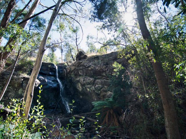
Stanley Park Falls, Daylesford
Stanley Park Falls is set within a dense bush. (Credit: Visit Macedon Ranges)

This small hidden waterfall is tucked away in the Stanley Park reserve, where you’ll also find picnic areas, a playground, BBQ facilities, toilets and walking tracks (keep an eye out for koalas!).

Fed by Turitable Creek, the cascade flows over rocky ledges into a small, fern-lined gully. Check it out from the platform right by the top of the falls, or take the stony steps down to the gully, then follow the walking track to the base of the falls. With all of the park’s facilities, this is a top spot to set up picnic for the afternoon.

Distance from Daylesford: 48-minute drive
Where: Stanley Park, 15 Salisbury Rd, Mount Macedon
Parking: Yes
Difficulty: Easy to moderate
Swimming: No

Jade Raykovski
Jade Raykovski is a freelance travel writer from Melbourne, Australia whose wanderlust began from immersing herself in the fantasy worlds of her favourite books as a kid. She started off her career as a graphic designer, before making the switch to copywriter, and now – in what you could say is the role she was always destined for – travel writer. Along with Australian Traveller, her bylines include National Geographic, BBC Travel, Escape and NZ Herald. And while she loves writing about home, she'll never pass up the chance to sip a spritz in Italy.
View profile and articles

From coast to bush: these are Gippsland’s best hikes

    Michael Turtle Michael Turtle

    Video credit: Tourism Australia

    From coast to mountains, hiking in Gippsland offers a stunning array of landscapes, with trails that take you deep into the region’s heritage.

    I step out onto the sand and it cries out underfoot. Kweek! I take another step and there’s another little yelp. Screet! Picking up the pace, the sounds follow me like my shadow, all the way down to the water. It’s obvious how this spot got its name – Squeaky Beach – from the rounded grains of quartz that make the distinctive sounds under pressure.

    For many, Wilsons Promontory National Park is the gateway to Gippsland, and the best way to explore it is by walking its network of hiking trails, from coastal gems such as Squeaky Beach through to the bushland, among the wildlife. But it’s still just a taste of what you’ll find on foot in the region.

    Venture a bit further into Gippsland and you’ll discover the lakes, the rainforest, and the alpine peaks, each changing with the season and offering summer strolls or winter walks. Just like that squeaky sand, each step along these trails has something to tell you: perhaps a story about an ancient spirit or a pioneering search for fortune.

    The best coastal hikes in Gippsland

    sunset at Wilsons Promontory National Park
    Wilsons Promontory National Park is a sprawling wilderness with many coastal bushland trails. (Image: Mark Watson)

    Wilsons Promontory National Park (or ‘The Prom’, as you’ll end up calling it) is an easy three-hour drive from Melbourne, but you might ditch the car when you arrive, with much of the park’s 50,000 hectares accessible only by foot. From the inky water of Tidal River (dyed dark purple by abundant tea trees), I like the easy walks along the coast, among lichen-laden granite boulders, to golden beaches and bays.

    a couple on Mount Oberon
    Panoramic views from the summit of Mount Oberon. (Image: Everyday Nicky)

    The trail to the panoramic views at the summit of Mount Oberon is a bit harder, up steep timber and granite steps, but it’s a popular 6.8-kilometre return. The more remote hikes are found through the open banksia and stringybark woodland of the park’s north, or along the multi-day Southern Circuit, which ranges from about 35 to 52 kilometres, with sunrises and sunsets, kangaroos and cockatoos, and maybe even whales.

    a golden sand beach at Wilsons Promontory National Park
    Walk ‘The Prom’s’ golden sand beaches. (Image: Tourism Australia/Time Out Australia)

    You might also see whales on the George Bass Coastal Walk, even closer to Melbourne on the western edge of Gippsland. This dramatic seven-kilometre trail along the clifftops takes in sweeping views of the wild ocean, occasionally dipping down from grassy green hills to coastal gullies and a secluded beach. It also now links into the Bass Coast Rail Trail for an extra 14 kilometres.

    the George Bass Coastal Walk
    George Bass Coastal Walk trails for seven kilometres along clifftops. (Image: Visit Victoria/Time Out Australia)

    Over at the eastern edge of Gippsland, in Croajingolong National Park, you can wander along the lakeshores beneath koalas and around goannas (I keep my distance since one chased me here!). For those who are even more adventurous, the park is also the starting point for the 100-kilometre Wilderness Coast Walk, usually done over seven days.

    the Croajingolong National Park, Gippsland
    Wander along the lakeshores in Croajingolong National Park. (Image: Tourism Australia)

    The best bush hikes in Gippsland

    the Baw Baw National Park
    The alpine heath of Baw Baw National Park. (Image: Everyday Nicky)

    Deep in the Long Tunnel Extended Gold Mine at Walhalla, mining guide Richard tells me how this small town in the mountains east of Melbourne boomed when prospectors found gold here in 1862. These days, you’ll find most of the town’s treasure – its heritage – above ground, with the Walhalla Tramline Walk a wonderful way to explore it.

    Just seven kilometres long, the walk takes you through decades of Gold Rush history, following the original rail trail from lush bushland to the mining sites, and through the charming village of just 20 residents with its wooden cottages and old shopfronts adorned with turn-of-the-century advertising posters. Blazing a trail where trailblazers once opened up the region, this is also the starting point for the 650-kilometre Australian Alps Walking Track.

    Nearby, Baw Baw National Park has walks through gnarled snow gums and alpine heaths that show off the colourful wildflowers in summer and the pristine carpet of white in winter. Several trails are perfect for snowshoes, including a 45-minute route from St Gwinear up to vast views across the Latrobe Valley.

    Further up into the mountains, the Toorongo and Amphitheatre Falls Loop Walk is an easy 2.2-kilometre path that serenades you with the sound of flowing water as you pass mossy rocks and tree ferns en route to two sets of waterfalls cascading over boulders in the remote wilderness.

    The best cultural hikes in Gippsland

    the Mitchell River National Park, Gippsland
    Hike the Mitchell River National Park. (Image: Parks Victoria/Grace Lewis)

    Across a pool in a natural sandstone amphitheatre, deep within a cave behind a waterfall, it’s said the Nargun has its lair. A fierce creature, half human and half stone, that abducts children and can’t be harmed by boomerangs or spears, the story of the Nargun has been told around the campfires of the local Gunaikurnai people for generations.

    As a culturally significant place for women, hikers are asked not to go into the Den of Nargun, but a 3.4-kilometre loop walk leads you through a rainforest gully to the entrance where you can feel the powerful atmosphere here in Mitchell River National Park, along Victoria’s largest remaining wild and free-flowing waterway.

    the bee-eaters at Mitchell River National Park
    Bee-eaters at Mitchell River National Park. (Image: Parks Victoria/Grace Lewis)

    The Den of Nargun is part of the Bataluk Cultural Trail, a series of important traditional Gunaikurnai sites through central Gippsland. Another location is Victoria’s largest cave system, Buchan Caves Reserve, with trails to important archaeological sites of human artefacts up to 18,000 years old. The FJ Wilson Interpreted Walk includes the naturally sculpted white limestone steps of the 400-metre-long Federal Cave, while the Granite Pools Walk goes among tall timber and moss-covered gullies.

    the ancient rainforest of Tarra-Bulga National Park
    The ancient rainforest of Tarra-Bulga National Park. (Image: Josie Withers)

    Also important to the Gunaikurnai people is Tarra-Bulga National Park, known for its ancient myrtle beeches and enormous mountain ash trees. Just 40 minutes return, the Tarra Valley Rainforest Walk offers a taste of this verdant landscape, while the Grand Strzelecki Track takes you deep into the lost world of forest giants on an epic 100-kilometre trail rich with tradition.

    A traveller’s checklist

    Staying there

    the WildernessRetreats in The Prom
    Wilderness Retreats in The Prom. (Image: Christian Pearson)

    Wilderness Retreats in Wilsons Promontory offers glamping-style tents with luxurious queen beds. Star Hotel is a reconstruction of a Gold Rush-era hotel from 1863 in the heart of heritage Walhalla. Caves House is a historic three-bedroom house with views over the Buchan River.

    Eating there

    the Carrajung Estate, Gippsland
    Enjoy a post-hike lunch at Carrajung Estate. (Image: Everyday Nicky)

    Kilcunda General Store serves great coffee and meals of local produce at the George Bass Coastal Walk. Alpine Trout Farm is located near Toorongo Falls in Noojee. Fish for your own lunch and barbecue it with the provided cookware.

    Carrajung Estate is a short drive from Tarra-Bulga National Park. The winery’s restaurant offers a seasonal menu of regional ingredients and you can stay at The Lodge.

    a seafood feast at Carrajung Estate, Gippsland
    The table is set for a seafood feast at the estate.

    Video credit: Tourism Australia