hero media

The secret pink cliffs of Victoria you need to see to believe

A little slice of paradise – but make it pink.

Victoria’s gold rush left plenty behind – an economic boom, population growth and a rich history that lives on today. But perhaps its most surprising legacy is the Pink Cliffs Geological Reserve. Carved out by mining and reclaimed by nature, these pastel-hued formations are one of the country’s best-kept secrets.

A quick history of the Pink Cliffs

Back in the 1880s, gold miners descended on the rural Victorian town of Heathcote, following news of an untapped alluvial goldfield. To access its riches, hydraulic sluicing was carried out across the site, a mining technique that uses high-pressure jets of water to blast away large chunks of earth.
The Pink Cliffs Geological Reserve in Heathcote, Vic
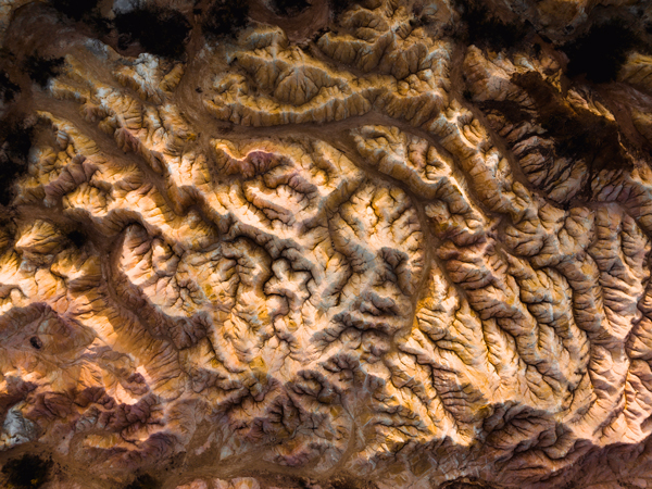
Extensive hydraulic sluicing resulted in a carved-out landscape. (Image: Visit Victoria)

Hydraulic sluicing has since been recognised as a method that wreaks serious environmental havoc. But it’s also the reason this land looks the way it does today – a 30-hectare vista of mini gorges and cliffs, dotted with native flora that has found life in its ravaged crevices. Now known as the Pink Cliffs Geological Reserve, the site is listed on the Victorian Heritage Register and identified as a Terrestrial and Inland Waters Protected Area by the state government.

Why is it called the Pink Cliffs Geological Reserve?

As humans often do, we managed to find beauty in the midst of destruction. And while many tourists visit the reserve to learn about its gold-rush history, it’s become popular for another reason entirely.
The Pink Cliffs Geological Reserve in Heathcote, Vic
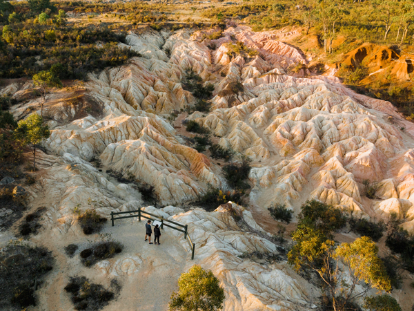
The site has since become popular for its pink-hued cliffs. (Image: Visit Victoria)

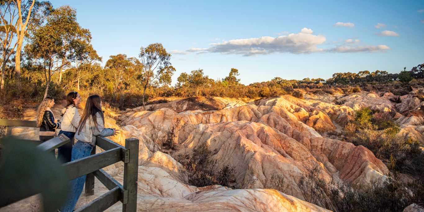
Yes, plenty of gold was found here. But the Pink Cliffs Geological Reserve is also rich in smooth ironstone and a naturally occurring pink clay. The powder-like texture of the clay, combined with the distinctive volcanic appearance of the ironstone, creates a lunar-like landscape reminiscent of a sunrise in summer.

Similar to places like Uluṟu and Mungo National Park, the formations reflect the sun’s rays to create a constantly changing canvas of colour – shades of orange and pink that dance and dip across the site. The cliffs and gorges seem otherworldly, more like the blushing canyons of Mars than country Victoria.

Need tips, more detail or itinerary ideas tailored to you? Ask AT.

AI Prompt

A day-tripper’s guide to the Pink Cliffs

The Pink Cliffs Geological Reserve is easy to experience within a day, making it the perfect pit stop on a classic Victorian road trip. For those coming from Melbourne, it’ll take you roughly 1.5 hours, while nearby Bendigo is only a 35-minute drive away.

Once you’ve arrived, take the easy 30-minute loop from the car park, which weaves through eucalypt forests and past educational information signs. There are multiple viewing platforms along the way that showcase the pink peaks and volcanic-like gorges from different perspectives, so don’t forget your camera!
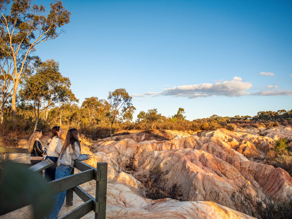
The Pink Cliffs Geological Reserve in Heathcote, Vic
Admire the geological wonder from multiple viewing platforms. (Image: Visit Victoria)

While the reserve is an absolute highlight, this picturesque pocket of Victoria has plenty more to offer visitors. Oenophiles should head to one of the region’s vineyards, like Silver Spoon Estate, for an afternoon tipple. If you’re more of a hophead, check out nearby Tooborac Brewery. For more natural beauty, hit the walking trails of Heathcote-Graytown National Park or make the 20-minute drive to Lake Eppalock for a refreshing dip. Craving more colour? Be sure to add Australia’s pink lakes to your bucket list too!

If you’re short on time, don’t sweat it – the Pink Cliffs Geological Reserve is worth the trip alone. Just remember to stick to all designated pathways and avoid touching anything beyond the fences. This fragile landscape has endured enough – let’s protect it for generations yet to come.

Want to see more stories from Australian Traveller in your Google search results?

  1. Click here to set Australian Traveller as a preferred source.
  2. Tick the box next to "Australian Traveller". That's it.
Taylah Darnell
Taylah Darnell is Australian Traveller's Writer & Producer. She has been passionate about writing since she learnt to read, spending many hours either lost in the pages of books or attempting to write her own. This life-long love of words inspired her to study a Bachelor of Communication majoring in Creative Writing at the University of Technology Sydney, where she completed two editorial internships. She began her full-time career in publishing at Ocean Media before scoring her dream job with Australian Traveller. Now as Writer & Producer, Taylah passionately works across both digital platforms and print titles. When she's not wielding a red pen over magazine proofs, you can find Taylah among the aisles of a second-hand bookshop, following a good nature trail or cheering on her EPL team at 3am. While she's keen to check out places like Scotland and North America, her favourite place to explore will always be her homeland.
View profile and articles
hero media

The road trips and trails you need to experience in Victoria now

    Kellie Floyd Kellie Floyd
    Wind through fern tunnels, stop for a wine in a tram bar, or chase giant murals across the wheatbelt. These drives and rides prove Victoria’s best stories are found off the straight and narrow. 

    There’s something unmistakably Australian about a road trip: car packed, playlist on, landscapes shifting. Travelling down the highway toward Healesville, in Victoria’s Yarra Valley, the mountains rise, flanking me on both sides. I feel its embrace, a silent invitation to explore what lies beyond.  

    Moss-covered embankments rise on either side, and towering mountain ash trees form a green tunnel overhead. Road signs warn of wombats and cyclists but with giant ferns lining the roadside, the landscape feels prehistoric, as if a dinosaur might suddenly emerge. This, the Black Spur, is one of my favourite road trips. 

    The Black Spur 

    The Black Spur drive
    Through the forested canopy of The Black Spur drive that winds from Healesville to Narbethong. (Image: Neisha Breen)

    Location: Yarra Ranges
    Duration: 30 kilometres / 30 minutes 

    The Black Spur is short compared to other Victorian road trips, just 30 kilometres, stretching from Healesville to Narbethong. But what it lacks in distance, it makes up for in scenery. Just outside Healesville, Maroondah Dam offers bushwalks and scenic views. However, if pressed for time, Selover’s Lookout is an easy roadside stop offering uninterrupted views of the dam.  

    In Narbethong, close to the Marysville’s snowfield, is the Black Spur Inn, a charming double-storey brick hotel that’s been welcoming travellers since 1863. Here, diners cosy up by the roaring fire or gaze through the floor-to-ceiling windows, imagining horse-drawn coaches carrying hopeful gold seekers to the eastern goldfields.   

    Victoria’s Silo Art Trail 

    Silo Art Trail
    The Silo Art Trail in the Wimmera Mallee region. (Image: Visit Victoria/Anne Morely)

    Location: Various towns across the Wimmera Mallee region
    Duration: More than 200 kilometres / 4–5 hours but best over a minimum of three days  

    What began as a way to draw travellers back into town bypassed by highways – places such as Nullawil, Sea Lake and Patchewollock – has grown into a celebrated outdoor art movement. The Silo Art Trail now includes 23 silos, each transformed with large-scale mural portraits sharing local stories, celebrating community heroes, Indigenous history, farming life, or regional identity.  

    The Nullawil silo, for example, is a portrait of a local farmer in a chequered flannelette shirt alongside his loyal kelpie, painted by artist Sam Bates (AKA Smug). And the silos at Albacutya in the Grampians, painted by artist Kitt Bennett, depict her joyful memories of growing up in the countryside. Many of the murals sit right in the heart of small towns, such as Rochester and St Arnaud, making them perfect spots to pause for a country pub meal or something sweet from a local bakery.   

    Metung to Mallacoota  

    Gippsland lakes
    Gippsland Lakes. (Image: Visit Victoria/Josie Withers)

    Location: Gippsland
    Duration: Approximately 220 kilometres / 4 hours  

    The Gippsland Lakes are a much-loved holiday spot in Victoria, but road-tripping further east reveals much more. Begin in Metung and time your visit with the monthly farmers’ market, or simply linger over lunch on the lawn of the Metung Hotel. Twenty minutes away is Lakes Entrance, where you can watch the fishing boats return with their catch. 

    Lakes Entrance
    Lakes Entrance. (Image: Visit Victoria/Iluminaire Pictures)

    Continue to Marlo, where the Snowy River spills into the sea, and Cape Conran for its many beaches and walks. If needing to stretch your legs, Croajingolong National Park is home to the historic Point Hicks Lighthouse and the Wilderness Coast Walk. Birdwatching and rainforest trails near Bemm River are worth a pit stop before arriving in Mallacoota, where the forest meets the sea. 

    Great Ocean Road 

    12 Apostles on the Great Ocean Road
    The 12 Apostles on the Great Ocean Road. (Image: Tourism Australia/Two Palms/Harry Pope)

    Location: South-west Victoria, from Torquay to Allansford
    Duration: Approximately 250 kilometres / 4–5 hours but best over a minimum of three days  

    Victoria’s most famous road trip delivers it all: world-class surf breaks, rainforest walks, clifftop lookouts and wildlife encounters. The journey begins in Torquay, the state’s surf capital, then hugs the coast past Anglesea and Lorne to Apollo Bay, before curving inland through the lush rainforest of the Otways. Stop at Cape Otway Lightstation or take to the treetops at Otway Fly.  

    Between Cape Otway and Port Campbell lies the most photographed stretch – seven of the Twelve Apostles still standing, alongside the golden cliffs of Loch Ard Gorge. Further west, Warrnambool is a winter whale-watching hotspot, before the road winds to Port Fairy, a charming fishing village of whalers’ cottages, walking trails and offshore seal colonies further along the coast. 

    Bellarine Taste Trail 

    Terindah Estate
    Terindah Estate. (Image: Visit Victoria/Emily Godfrey)

    Location: Bellarine Peninsula
    Duration: Approximately 80 kilometres / 2–3 hours  

    The Bellarine Taste Trail is a feast for the senses, winding through coastal towns, past boutique wineries and artisan producers. It’s a choose-your-own-adventure style trail – simply grab a map and build your own delicious journey.  

    You might wander historic, seafront Queenscliff, sip wine in a converted tram bar at Terindah Estate, sample a locally distilled whisky at The Whiskery in Drydale or pick up a jar of honey at Wattle Grove in Wallington. Seafood lovers can head to Portarlington, famous for its mussels. Eat them fresh at local restaurants or head out on the water with Portarlington Mussel Tours. 

    O’Keefe Rail Trail – Bendigo to Heathcote 

    Pink Cliffs Reserve
    Pink Cliffs Reserve in Heathcote can be seen on the O’Keefe Rail Trail. (Image: Visit Victoria/Emily Godfrey)

    Location: Central Victoria
    Duration: Approximately 50 kilometres / 4 hours cycling 

    Travellers first journeyed between Heathcote and Bendigo in 1888, when the railway line was built to link the towns. Trains stopped running in 1956, but today the route has a new life as the O’Keefe Rail Trail. The path is mostly level for easy riding, and along the way you’ll cycle past bushland, waterways and reserves. There are plenty of places to picnic, birdwatch, and if you’re lucky, spot a platypus.  

    The trail is well supported with water stations, bike repair points, shelters, and signage. Axedale makes a great halfway stop, with the pretty Campaspe River Reserve for a rest and local cafes for refuelling. Begin in Heathcote, known for its wineries and cafes, or in Bendigo, which is easily reached by train from Melbourne/Naarm. Shorter sections, such as Heathcote to Axedale, are also popular. 

    Goldfields Track – Ballarat to Bendigo 

    Location: Central Victoria
    Duration: Approximately 210 kilometres / 2–3 days cycling  

    The Goldfields Track traces a route once so rich in gold it made Melbourne one of the wealthiest cities in the world. Starting at Mt Buninyong, south of Ballarat, the trail leads mountain cyclists and walkers north through Creswick, Daylesford and Castlemaine before finishing in Bendigo. Along the way, you’ll encounter granite outcrops, eucalypt forests, rolling farmland and remnants of the region’s mining past.  

    As it passes through the lands of the Dja Dja Wurrung and Wadawurrung people, the track shares gold rush history and Indigenous stories brought to life by interpretive signs. Walk or ride the full trail or choose from one of its three distinct sections. With cosy stays, cafes and pubs, it’s easy to mix wilderness with comfort.